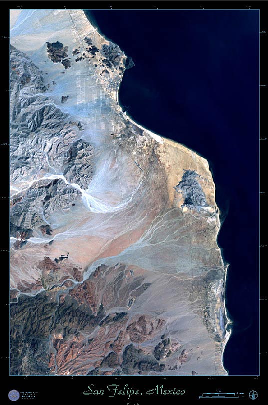
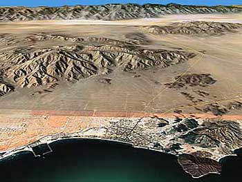
Located
120 miles south of the Mexican border on the northwestern
Baja, San Felipe is an entertainment, a frustration,
a wonder and a paradox. It is nestled in the northern
hook of the Bahia de San Felipe, between Punta
El Macharro and Punta Estrella. The convergence
of the Sierra San Felipe and the San Pedro
Martir ranges form a wide, rocky horseshoe. A few
adventurous peaks break away from this formation and
collect on the east side of Highway 5. The town of San
Felipe leans like a small book of sonnets against two
of these sloping giants. To the west, through sheer
energy of disposition, the parent range continues its
errant and unathletic run southward another hundred
miles. Unassuming in the eyes of a true mountain man,
the range is impressive enough to the citizens of San
Felipe. Picacho
del Diablo, one of its peaks, shoulders up
over ten thousand feet into the air. In winter, its
summit is often a claw of snow and ice. For those who
have uncontrolled geologic zeal, try this
site for a chiropractic history of the Baja's granite
bones.
It is nearly always sunny in San Felipe, warm for most
of the year and something of a smithy's forge in the
summer months. This is because the town has chosen to
sleep in a desert, part of the Gran Desierto, the scorched,
juiceless area that begins in the northwestern corner
of the state of Sonora.
Of course, without water there can be no community.
But San Felipe is blessed with reasonably clean water,
drawn from an underground river located several miles
south of town. The water is piped through pumping stations
into town and plumbed into homes that can afford it
or transported in pipas, great lumbering trucks with
huge sloshing water tanks on their backs. These trucks
supply the outlying campos and communities.
Because the water is not immediately potable, being
slightly saline straight from the ground, several filtration
stations were built to provide the town with drinking
water.
History
The history of San Felipe is much like the history
of mankind itself, which is believed to begin with God
and suspected to end with greed.
The first European to set foot on the sands of what
he called San Felipe de Jesus, was the Jesuit Padre
Juan de Ugarte, in 1721. De Ugarte was exploring the
inner coast of the Baja. Twenty five years later Father
Fernando Consag, another Jesuit, mapped the area and
marked the location of the bay. In the late eighteenth
century the Dominicans, third and last of the religious
orders to embrace the indigenous peoples of the Baja
Peninsula with their dogmas, attempted to make San Felipe
a supply post for its northern missions. Attacks on
their storage sheds and supply trains by the aggressive
Yuma Indians persuaded the Dominicans to relocate their
depositories to the Pacific coast.
In the mid-eighteen hundreds, gold fever seemed to
grip the entire west coast of North America. Prospectors
flooded over the American borders into Mexico and shacks
began to spring up in the San Felipe area. But when
the mines didn’t yield as expected, the shacks
were left to the heat and wind. Plans to develop San
Felipe as a mining port were abandoned.
In 1855, Guillermo Andrade leased 30,000 hectares around
the bay. In 1876, he made a contract with the Federal
Government to colonize the area, but died before he
could complete his project.
In the early nineteen hundreds the governor of the
territory, Coronel Esteban Cantú Jiménez moved the capital
of Baja from Ensenada to Mexicali. He planned to connect
the new capital by roads and railway to a young port
at San Felipe. In 1916, Coronel Cantú began the first
of three expeditions to San Felipe. Problems and supply
shortages aborted the first two journeys, but the third
one was successful. It was Governor Cantú's engineers
who built the first car-access road to San Felipe. Cantú's
administration permitted precious metal prospecting
in the area and that is what attracted the first white
'settlers'. But available funds could not support his
ambitions and again San Felipe was abandoned. The San
Felipe property purchased by Cantu gradually moved into
the hands of his descendants, where it appreciated in
value merely from proximity to someone else's partially
realized or failed real estate scheme.
In the 1940's, ex-President of Mexico Aberlardo Rodríguez,
wanting to increase tourist activity in the area, graded
and paved Cantú's deteriorating road. At the same time,
his brother José María Rodríguez Luján, who owned over
4,000 hectares of San Felipe, established the Port of
San Felipe and other enterprises.
Commercial benefits began to attach themselves to San
Felipe as the Colorado River was harnessed to provide
irrigation to the farmlands of the Imperial Valley to
the north. Mexicali slowly became an oasis of rich,
arable land and the population increased. During the
Second World War, the American Army's Corps of Engineers
constructed a usable road to San Felipe where it built
a Submarine-Watch Station. Sharks began to be harvested
for their livers, which were discovered to contain ten
times the amount of vitamin A as the livers of codfish.
Alongside this enterprise, local Chinese shipped the
bladders of the huge totuava fish back to China where
they were dried and ground into powders used to enrich
and thicken soups. When two American entrepreneurs saw
the great corpses of the bladderless totuavas simply
pushed into the surf, they began their own business
by hauling ice from across the border and transporting
the fish to California, where they were sold to restaurants
as "sea bass".
Then a former Mexican president, Ableardo Rodriquez,
and a lawyer named Guillermo Rosas, seeing the generosity
of the sea's abundance, purchased a large part of the
village. They planned to make San Felipe the center
of a tourist sports fishing industry.
They sent an American fisherman into the area to assess
the angling potential of the surrounding waters. Two
years later the road was improved and the town began
to attract tourists, both for its beauty and its sport
fishing.